 |
| Image Source: Rudolph Musngi |
When you have
first read the title “Rizal”, most of you would have first thought that this
blog post would be about the Philippines’ National Hero Dr. Jose Rizal. Well,
you are almost right, but what I am talking about is the province of Rizal.
Rizal was named in honour of our hero, Dr. Jose Rizal. It is also known as the
“Cradle of Philippine Art”.
WHY? It is
where Angono is located. Angono is the home of highly acclaimed artists and
musicians, including two National Artists namely maestro Lucio San Pedro and
painter Carlos Botong Francisco.
Having the
advantage of being an urbanized area but still preserving its agricultural
area, it offers diverse natural, cultural, and man-made attractions. From the
scenic view of Sierra Madre Mountains to the breathtaking view of Laguna de
Bay, one should not miss visiting Rizal at least once in their life. It also
has swimming spots, picnic grounds, commercial centers, industrial parks, and
convention halls.
Rizal also has a rich history that can be traced down even before the Spaniards came to the country.
The inhabitants of Rizal province of yore enjoyed the best of two shores — the seashore of Manila Bay on its western fringes with its famous sunset, and the lakeshore of Laguna de Bai at its eastern border, noted for its picturesque view of the Philippines’ largest inland body of water. Laguna de Bai named after the Laguna town of Bai, which used to be the biggest settlement along the western edge of Asia’s second largest freshwater basin, looks like the cavity of the human heart. The dagger-shaped Talim island lying in the middle divides the lake into two sections, along with three islets hugging the island’s coast. During the pre-Spanish times, the settlements located along the lakeshore of Laguna de Bai (Bay) and on the southern banks of the Pasig River were ruled by Rajah Soliman, nephew of Rajah Lakandula, the chief of Tondo.”
(Source: http://rizalprovince.ph/)
 |
| Image Source: Wikipedia |
It is located
near Metro Manila, making it as Metro Manila’s “closest eastern neighbour”. It
is bordered by the province of Bulacan on the north, Quezon to the east, and
Laguna to the south. It is a mountainous province located on the western slopes
of the southern portion of Sierra Madre mountain range. Now, you will not
wonder anymore why the roads go uphill when going to Rizal.
Rizal is subdivided
in to 4 political districts, 13 municipalities, and one city.
The First District consists of Antipolo City, Angono, Binangonan, Cainta, and Taytay.
The Second District consists of Baras, Cardona, Morong, Jalajala, Pililla, Rodriguez, San Mateo, Tanay, and Teresa.
The First District consists of Antipolo City, Angono, Binangonan, Cainta, and Taytay.
The Second District consists of Baras, Cardona, Morong, Jalajala, Pililla, Rodriguez, San Mateo, Tanay, and Teresa.
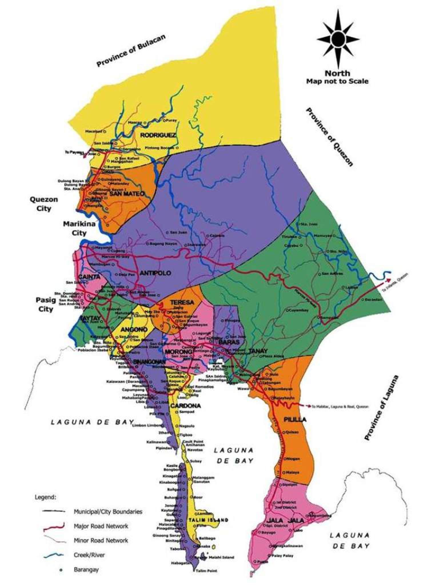 |
| You can see Bulacan, Laguna, and Quezon bordering the province of Rizal Image source: Rizal Province |
LANGUAGE
The
predominant language is Tagalog while English is the second language. English
is used as the medium of communication in education and business.
CLIMATE
Rizal only has the wet and dry seasons. It is relatively dry from December to May, and wet during the rest of the year. Northeast winds prevail in the province. It is said to be not directly hit by typhoons, low-pressure systems, and strong winds.How to get there:
Estimated
travel time: 1 hour and 05 minutes
The
province is accessible from Manila via Ortigas Avenue, and from Quezon City via
Marcos Highway and Sumulong Highway.
Via private
vehicles
1. It can be
accessed from Ninoy Aquino International Airport (NAIA-Pasay), through the
following waypoints; NAIA Road turn right to Roxas Boulevard turn right to EDSA
and then turn right at EDSA-Ortigas Avenue Interchange or from NAIA to Pres.
Carlos P. Garcia Ave. (C5) turn right at C5-Ortigas Avenue Interchange going
all the way to Rizal Province area.
2. Another
access point from Metro Manila is Aurora Boulevard to Marcos Hi-way going
Cainta and Antipolo City. To get to the towns of San Mateo and Rodriguez
(Montalban) use Commonwealth Avenue to Batasan-San Mateo Road as altenate route
from Metro Manila.
3. From the
southern provinces use provincial roads entering SLEX, then turn right to SLEX
and C5 Interchange or use the Laguna-Rizal Provincial Road as alternative
route, and from northern provinces use North Luzon Expressway (NLEX) and
turning left to EDSA at Clover Leaf Interchange you can turn left to Aurora
Boulevard or at EDSA-Ortigas Avenue Interchange.
Via Public transportation
·
You
can hop and drop to public utility vehicles like jeepneys or FX Taxis (AUVs)
with terminals located in Crossing and SM Mega Mall in Mandaluyong City and in
Cubao, Quezon City.
(Source: http://rizalprovince.ph/howtogethere.html)
 |
| Image Source: Rizal Province - Islands Philippines |
Want to know more about the province of Rizal? Wait for next week’s blog post about 5 Best Things to do in Rizal!
No comments:
Post a Comment